Traffic
Road and street network and vehicle traffic
CURRENT SITUATION
The vehicles access road to the Student City complex is achieved from the direction of all peripheral communication routes, except from the direction of the traffic route (exit) from the Highway towards the Tošin Bunar St., i.e. from the Tošin Bunar St., Zorana Đinđića Blvd and Studentska Street.
In the context of the city traffic network, all these communication lines are characterized by high ranking and traffic frequency, apart from the Studentska Street. All of them have been cadastrally fixed in relation to the competition area, which means that there are no plans to change their defined regulation, while the level of implementation of their traffic profile and route varies.
Tošin Bunar Street, which is located in the functionally ranked city traffic network in the zone that neighbors the area that is the subject of the competition, is classified as a communication line of the first rank; it has two traffic lanes in each direction, with an extension for one / one each near intersections, and sidewalks on both sides with a width of 3.0-5.0 meters.
Zorana Đinđića Blvd, which is located in the functionally ranked city traffic network in the zone that neighbors the area that is the subject of this competition, is also classified as a communication line of the first rank; in its current condition and compared to its design documentation, it has been implemented in its full profile. This profile consists of 3 vehicle lanes, with a total width of 9.0 meters - two of them in the eastern direction and one towards the west, with an extension near intersection and sidewalks on both sides with a width of 3.0 meters each. Bicycle lanes are located within the sidewalk profile, with a width of 1.10 meters on each side.
Traffic link (exit) from the city Highway towards the Tošin Bunar Street, which belongs to the highway system within the functionally ranked city traffic network, operates with a variable profile in the zone that is the subject of this competition. In the first segment (in relation to the Highway), this profile consists of two one-way traffic lanes with a total width of 7.0 m and a sidewalk near the Student City complex with a total width of 9.0 m, which also includes the stairway in the underground passage below the highway towards Block 37. Continuing towards the Tošin Bunar St., the profile now consists of two traffic lanes that are partially separated with a green island with a total width of all segments varying between 7.0 m and 18.0 m, as well as a sidewalk near the Student City complex with a width of 6.0 m. This first segment also includes the “hub” of the connection with the Studentska Street, which is not operational.
Studentska Street, located in the zone that neighbors the area that is the subject of this competition, functions as an access road that provides access to the Main Gate of the Student City and the eastern part of Block 34; it is not ranked within the functionally ranked city traffic network. In its constructed section, the Studentska Street has a full profile that consists of two-way sidewalk with a total width of 7.0 m a sidewalk with a width of 3.0 m on each side.
PLANNED SITUATION
According to the official planning documentation for Tošin Bunar Street within the zone that is covered by this competition, widening of the regulation towards the west up to the total width of 35.85 m is in the plans, which will result in a new and better traffic profile. The new profile will consist of the following: two traffic lanes in each direction with a total width of 7.0 m each, with a separating green island (4.5 m), parking space (5.0 m), sidewalk (3.0 m) and a green area (1.35 m) towards the western regulation, and the sidewalk (3.0 m), bicycle lane (2.5 m) and green area (3.5 m) towards the eastern regulation, i.e. towards the Student City complex.
Excerpt from the Plan of Detailed Regulation of the Part of Tošin Bunar Street between Ivićeva Street and the Highway, The Official Gazette of the City of Belgrade No. 99/16, attached with the competition documentation - III EXCERPTS FROM URBAN PLANNING DOCUMENTS
Traffic Link (exit) from the city Highway towards the Tošin Bunar St. has the potential for creation of a bicycle lane within the current sidewalk profile with regulation towards the Student City complex (which is formally affirmed in the planning sense in the zone of connection with the Tošin Bunar St.), as well as the activation of connection of this traffic link with the Studentska Street, confirmed by the General Regulation Plan for the Construction Area of the Local Self-Management Unit - City of Belgrade, sections I-XI, “Official Gazette of the City of Belgrade” no. 20/16, 97/16, 69/17, 97/17, 91/20, 72/21 and 27/22 (hereinafter referred to as Belgrade GRP).
GRP of Belgrade stipulates the regulation of the Studentska Street along its whole route; within the zone that neighbors the area that is the subject of the competition, this entails the construction of the southern part of this street in the length of around 200.0 m, thereby fulfilling the full potential of the connection between the Studentska Street and the traffic link of the city Highway in the direction of Tošin Bunar St. Regulation defined by GRP also allows the implementation of the Studentska Street with the same profile that already functions in its existing part.
Public city transport
Competition area belongs to the Novi Beograd zone, with an operational subsistem of public city transport – the buss transport system. Bus stops are located at several locations in the imediate vicinity of the competition area – with traffic routes connected to Highway in the direction of Tošin Bunar St., bus stops Tošin Bunar St. and in Zorana Đinđića Blvd. - and they ensure a high-quality connection with all parts of the city, including the western suburban zones.
Pedestrian traffic
CURRENT SITUATION
Considering the movement of pedestrians in the surroundings of the competition area and within it, we can say that pedestrians enjoy good connections and appropriate and comfortable conditions for their movement, except in the zone of the unrealized segment of the Studentska Street route, which does not have pedestrian areas, forcing pedestrians to use an earthen path between the Student City bus station and the Main Gate of the Studentska City and Block 37 in all weather conditions.
PLANNED SITUATION
As it was previously mentioned in the Road and Street Network and Vehicle Traffic section, the official planning documents stipulate the regulation of Studentska Street along its complete route, and it is expected that the planned result will achieve a quality of connection and conditions of pedestrian movement that will be improved and adapted to the needs of all categories of users.
Bicycle traffic
CURRENT SITUATION
In the surroundings of the scope of competition, bicycle lanes have been formed only within the sidewalk in Zorana Đinđića Blvd, while the competition area itself lacks any bicycle lanes; a moderate bicycle traffic is mostly taking place within pedestrian communications.
PLANNED SITUATION
According to the current planning documentation, implementation of bicycle lanes is planned in the Tošin Bunar St., and potentially within the traffic link (exit) from the city Highway towards the Tošin Bunar St.
Green Areas
According to the Plan of General Regulation of Green Areas of Belgrade (The Official Gazette of the City of Belgrade No. 110/2019), there are no specifically categorized protected green areas in the competition area or in its immediate vicinity. This area belongs to the inner ring within the system of green areas of the city of Belgrade. The present green areas whose significance - taking into account their role within the landscape system of the city of Belgrade, especially in the connecting context, as well as their high atmospheric value - requires their preservation and improvement, are classified as green areas in public service (within competition area) or green areas in open residential blocks, and as an environmentally and esthetically functional urban space (in the immediate vicinity).
Infrastucture
Competition area and its immediate surroundings are adequately served by the system of infrastructural public utilities - which includes water supply, sewage, electrical power supply, telecommunications, heating and gas distribution systems.
Overview of routes of communal infrastructure is attached to the open competition documents - III EXCERPT FROM URBAN PLANNING DOCUMENTATION / EXCERPT FROM THE GENERAL REGULATION PLAN FOR THE CONSTRUCTION AREA OF THE LOCAL GOVERNMENT UNIT – THE CITY OF BELGRADE UNITS I-XIX, attachment NB 9.1-S - Overview of Infrastructure
Characteristics of the climate
The climate in Belgrade and its wider surroundings is moderately continental, with four seasons and around 2,096 sunny hours per year, with maximum average values in July and minimum average values in December.
Annual precipitation is mostly of the continental type, with a maximum in June. Average annual precipitation amounts to 670.0 mm and mostly consists of rain, and sometimes of hail, freezing rain and snow. April, June and December are the months with the largest number of days with precipitation.
Average monthly relative humidity ranges between 63% (in April and June) and 82% (in December).
In the context of Belgrade, the competition area belongs to the topographical and climatic zone of Novi Beograd, which is characterized by the average annual temperature of 11.9°C. Average monthly temperatures range between 0.0°C (in January) and 22.1°C (in July). During the summer months, there are days with daily temperatures above 35°C and tropical nights (with temperatures above 20°C) between June and August. The number of days with a temperature above 25°C is 95 per year.
Belgrade is a windy area that is exposed to southeastern, northeastern, northern and northwestern winds. The most frequent and strongest of them is the southeastern wind - koshava - which blows during the whole year, with a maximum in September and during winter and a minimum in June and July; it has an average speed od 25-45 km/h and storm gusts that can reach 130 km/h. The northwestern wind blows most frequently during summer months with a maximal average speed of 36 m/s. Northern and northeastern winds are the coldest winds in winter. Taking into account the position and morphology of the surroundings (natural and artificial), the competition area is equally and non-specifically exposed to all winds that are typical for Belgrade.
Current planning documents in the area of competition scope and its immediate surroundings
Current planning documentation in the competition area and its immediate surroundings consists of the following spatial and urbanistic plans:
- - General Regulation Plan for the Construction Area of the Local Government Unit – the City of Belgrade Units I-XIX, “The Official Gazette of the City of Belgrade” No. 20/16, 97/16, 69/17, 97/17, 91/20, 72/21 and 27/22 (hereinafter referred to as Belgrade GRP);
- Detailed Urbanistic Plan of the Highway Through Belgrade, “The Official Gazette of the City of Belgrade” No. 17/67;
- Plan of Detailed Regulation of the Part of Tošin Bunar Street between Ivićeva Street and the Highway, Municipal Buildings Zemun and Novi Beograd, “The Official Gazette of the City of Belgrade” No. 99/16;
- Plan of Detailed Regulation of the Part of the Area to the West from Tošin Bunar St. (between Arsenija Čarnojevića Blvd and Prilaz St.) to Marije Bursać St., Municipal Buildings Zemun and Novi Beograd, “The Official Gazette of the City of Belgrade” No. 69/21;
- Amendments to the Detailed Urbanistic Plan of BLOCK 4 in Novi Beograd, “The Official Gazette of the City of Belgrade” No. 14/91;
Planning basis for the area that is the subject of this competition is contained in the General Regulation Plan for the Construction Area of the Local Self-Management Unit - City of Belgrade Sections I-XIX, “The Official Gazette of the City of Belgrade” No. 20/16, 97/16, 69/17, 97/17, 91/20, 72/21 and 27/22 (hereinafter referred to as Belgrade GRP).
According to Belgrade GRP, competition area belongs to the Section IX - Novi Beograd Center, i.e. a segment of the Section IX, Original Novi Beograd, which mostly includes the initially constructed blocks, including the Student City and some of the blocks that were implemented later - Block 33 with the Western Gate of Belgrade and Retenzija.
The main characteristic of this area is the system of free construction of mostly residential and supporting facilities with the residential purpose, as well as individual and aggregated buildings intended for commercial and specialized central activities, in the area of spacious construction blocks. The Original Novi Beograd is characterized by a high degree of spatial and functional completeness. Newly constructed buildings, apart from the implementation of buildings that were previously planned but never built, are planned to be constructed in the zone of Tošin Bunar, after the completion of communication line in the new regulation and along the Highway. At the same time, these are the zones of new planned central activities. Transformation of a part of residential buildings into commercial facilities can be expected along the main traffic lines, but only in lower floors.
Excerpt from the General Regulation Plan for the Construction Area of the Local Government Unit – the City of Belgrade Units I-XIX, (The Official Gazette of the City of Belgrade No. 20/16, 97/16, 69/17, 97/17, 72/21 i 27/22.)
According to the Belgrade GRP, competition area belongs to Zone IX, Subzone “Original Novi Beograd”; in accordance with the latest revisions of GRP (“The Official Gazette of the City of Belgrade” 27/22) regarding its implementation, it is intended for direct application of the rule of construction in compliance with the GRP with the obligation to prepare the Urbanistic Project.
In accordance with the Belgrade GRP, competition area is planned to be a zone intended for public purpose - institution of higher education.

Figure 15 Excerpt from Belgrade GRP, attached figure 2-5.1 - Planned purpose of areas

Figure 16. Excerpt from Belgrade GRP, attached figure 6-5 - Areas intended for facilities and complexes of public services
URBANISTIC MEASURES FOR PROTECTION OF AREAS AND STRUCTURES (2.2)
PROTECTION OF CULTURAL PROPERTIES AND URBANISTIC PROTECTION
Section IX
Zones “Novi Beograd Center” and “Original Novi Beograd” are today one of the most representative and functionally most significant parts of Belgrade. Regarding the historical development of Belgrade, the modern city structure with open blocks, which has been continually built since the thirties of the last century to this day, is in a large part a heritage property and a testimony to commercial, administrative, urbanistic and cultural development of the city. Having in mind the fact that this part of the city was built in accordance with all the rules and principles of modern urbanism of the twentieth century, preservation of the chosen concept of construction is the primary goal, while at the same time the achieved quality should be maintained and improved.
The value of the historical, existing urbanistic and architectural concept of Novi Beograd, is defined with the aim to ensure its protection, preservation and improvement, taking into account both the aspect of protection of cultural heritage and the opinions of other professional organizations.
Cultural properties and previously protected properties within this planning area have a significant presence and spatial scope, which is why they require a more complex planning approach that would guarantee protection of existing properties and construction of new ones.
Taking into account the fact that protection, preservation and advancement of cultural heritage constitutes one of the most important elements of people’s identity, their culture and their perception of the space they live in, it is necessary to achieve intensive cooperation of all competent city institutions that will result in future planning solutions or activities aimed at direct implementation of this planning document.
There are 14 entities in total in the area of Section IX that have been granted the status of a cultural property or a property under previous protection; one of them is located in the immediate vicinity of the site - that is the RESIDENTIAL AND COMMERCIAL CENTER GENEX,41-43 Narodnih Heroja St. - Cultural Heritage Property, protection level 3.
Urbanistic protection of areas and structures
Urbanistic protection is a very significant segment of planning, whose purpose is to plan the total urbanistic and architectural heritage and include it in modern life of the city as one of the factors of its integrated development. Its mechanisms are intended to facilitate creation of an atmosphere whose anthropocentric quality should allow for creation of a living space that is esthetically and essentially acceptable. Mechanisms of urbanistic protection include horizontal and vertical regulation, preservation of silhouettes and visages, and application of materials, colors and architectural elements, allowing definition and recognition of the space and physical structure of a specific area.
Urbanistic protection of an area can be defined as planning in context. As such, it should value the created areas and structures from their urbanistic and contextual aspect and create planning preconditions for their protection.
In the context of urban renewal and urban regeneration and reconstruction, the field of creative and practical planning possibilities is much wider, since the subjects or urban renewal are most often the areas and locations characterized by larger capacities. In such areas, there is often a certain number of structures that constitute cultural properties and important urban landmarks whose existence can serve as a backbone of the identity of the area. In such circumstances, conditions and measures imposed by competent cultural heritage protection agencies can become a creative stimulant in the planning process.
Within the scope of this competition, there is one property that has been recognized as a value that deserves urbanistic protection in the category of Late Modernism - the Student Cultural Center (Student’s City Cultural Center), 179 Zorana Đinđića Blvd (1974, M. Mitrović) - in accordance with the criterion K8 - “Contextual value - the structure materially defines a high-quality urban atmosphere or participates with its stylistic values in the characterization of local setting.”
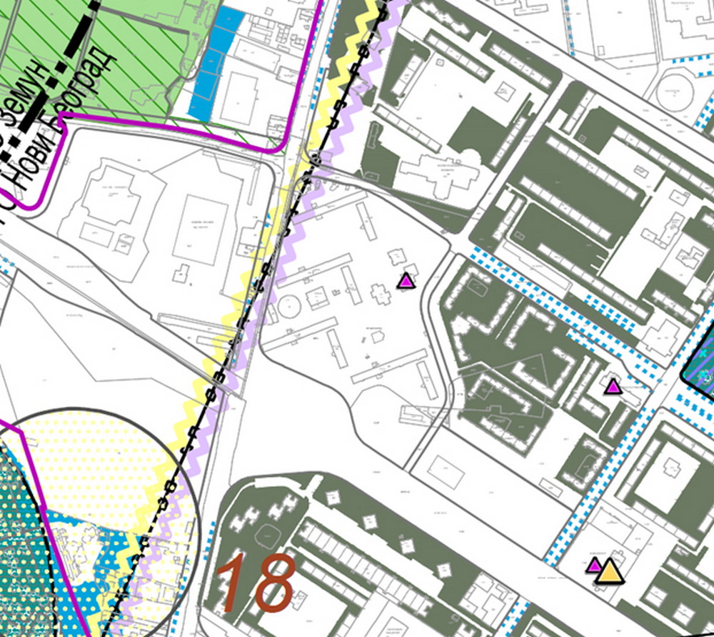

Figure 17 Excerpt from Belgrade GRP, attached figure 4-5.1 - Protection of natural and cultural values
DIRECT IMPLEMENTATION OF CONSTRUCTION RULES FOR STRUCTURES AND COMPLEXES OF PUBLIC SERVICES
HIGHER EDUCATION INSTITUTIONS - STUDENT CITY STUDENT STANDARD INSTITUTION - 9.J4.1


Figure 18. Excerpt from Belgrade GRP, attached figure 16-5.2 - Areas of direct implementation of construction rules
Purpose of areas
Main purpose: student standard institution - student dormitory. Spatial section “Student City” belongs to the institution “Student Center Belgrade”.
Within the new purpose, it is possible to implement complementary cultural facilities, and additional sport, commercial, catering and entertainment facilities that support the primary purpose and do not create noise.
It is possible to use basements and cellars for supporting and technical facilities of structures.
Number of structures on the land plot
It is allowed to build several structures on the land plot for the purpose of primary and complementary facilities, as well as technical infrastructure structures, in such a way that they create an integrated architectural and functional environment.
Requirements for formation of a building land plot
The plan defines a building land plot 9.J4.1 with the approximate surface area of 103.615 m2.
Parcellation of the planned building land plot is not allowed.
Cadastral land plots: 865/14, 865/15, 865/17, 865/28, 865/29, 866, 867, 868, 873, 874, 875, 876, 877, 878, 879, 880, 881, 882, 883, 884, 885, 886/1, 886/2, 887/4, 887/5, 912 and 914, all of them KO Novi Beograd.
Preparation of the Urbanistic Project is mandatory.
Phased implementation of the planned construction and reconstruction of the complex is allowed.
Plot coverage index
Maximal plot coverage index Z = 50%.
Maximal index of coverage of structures’ underground levels amounts to 70%.
Height of the building
Maximum height of the cornice of residential buildings is 32 m in relation to the zero level.
Maximal height of the cornice of additional facilities’ structures amounts to 12 m in relation to the zero level.
Maximal height of the cornice of the building/buildings of the student cultural center is 12 m in relation to the zero level. Exceptionally, the maximal height of the cornice may amount to 16 m if the programme specifies the need for that, in accordance with the technological composition of the structures.
Construction of new structures and position of structures on the land plot
The structures should be placed within the construction zone, which is defined by construction lines in appropriate graphical attachments with direct application of construction rules with elements of detailed elaboration. It is not required to place buildings or parts of buildings on the construction line, but within the area that is defined by construction lines.
Considering their position on the land plot, the structures are free-standing.
The building line of underground parts of the structures (garages etc.) corresponds to the above-ground building line.
Distance between structures on the land plot
The minimal distance between neighboring structures on the land plot amounts to one height of the taller structure if there are openings for residential rooms, or 1/2 of the height of the taller structure if there are openings of supporting facilities or no openings.
Ground floor level
Ground floor level of the buildings may be taller than the zero level by no more than 1.6 m


Figure 19. Excerpt from Belgrade GRP, attached figure NB 9.1-R - Regulation and levelling plan and parcellation plan
Requirements for free areas and green areas
The minimal percentage of open areas and green areas on the land plot is 50%.
The minimal percentage of green areas in direct contact with the ground on the land plot is 30%.
Preparation of technical documentation and establishment of the position of new structures requires manual valuation (bioecological foundation) of the existing vegetation in order to preserve it as much as possible.
Potential cutting of fully grown valuable tree specimens requires approval by the organizational unit of the City Department of Public Utilities and previous professional opinion of the expert commission for tree cutting.
The trees that are approved to be cut down should be replanted, if that is technically possible, within the existing complex or green areas that are located in the immediate vicinity.
The existing vegetation should be renewed.
Reconstruction of green areas should be performed using appropriate style, in accordance with the position of the buildings and their main purpose.
During landscaping, it is necessary to use native species of vegetation that belong to the realm of natural potential vegetation, adaptable to local environmental conditions; exotic specimens can be used if they have a confirmed and good ability to adapt to environmental conditions; seedlings from a plant nursery should be used; invasive and allergenic species should be avoided.
It is necessary to ensure a 1-2% gradient of communication surfaces to allow for drainage of surface waters towards porous soil or rainwater drains.
Porous or semi-porous sheeting should be used for communication surfaces.
It is possible to create green surfaces on roofs of the buildings as well as vertical vegetation on their facades; green areas on flat roofs of above-ground structures should be formed on a soil substrate that is at least 30 cm thick, while on roofs of underground garages this parameter should amount to at least 120 cm of soil substrate (this is not included in the total percentage of green surfaces that are in direct contact with the ground).
Preparation of the Landscaping and Architectural Design in accordance with conditions set by the Public Utility Company Zelenilo Beograd is mandatory.
Access to the land plot and parking
Vehicle and pedestrian access is provided by perimeter communication lines and the internal traffic network within the area as a whole.
A required number of parking places should be provided, within the land plot, in accordance with this norm: 1 parking spot / 3 employees.

Figure 20. Excerpt from Belgrade GRP, attached figure 3-5.1 - Traffic surfaces and the primary traffic network
Planned interventions
Construction of new buildings intended for accommodation of around 1,000 students is planned on the building land plot.
It is possible to extend or build on top of existing structures, in accordance with defined construction rules.
If there is a desire to build an additional floor on the existing building sections, it should be implemented within the dimensions of existing buildings on the basis of a mandatory structural analysis of existing structures.
On existing buildings, it is possible to perform adaptation, remedial works, energy efficiency upgrade, i.e. reconstruction of the thermal insulation of the building (facade walls, roof surface and transparent surfaces) with the aim to improve the category of the building from the aspect of energy efficiency.
Architectural shaping
During the implementation of the structure, it is necessary to achieve maximal usage of latest technical and technological solutions in the field of energy efficient construction.
The architectural expression must be modern, and it should match the atmosphere of an open block and the purpose of the area as a whole.
Energy efficient solutions should be used, i.e. significant percentage of the energy should be generated from renewable sources: heat pumps, solar panels and “green roofs” should be planned - extensive and/or intensive roofs.
It is possible to perform adaptation, remedial works, energy efficiency upgrade, i.e. reconstruction of the thermal insulation of the building (facade walls, roof surface and transparent surfaces) with the aim to improve the category of the building from the aspect of energy efficiency.
The top floor may be implemented in the form of a full floor or a loft.
Conditions for fencing of the land plot
The land plot is allowed to be fenced in accordance with technical, technological and security considerations.
Infrastructural networks
New buildings must be connected to the water supply and sewage networks, electrical power supply, telecommunication network, heating or gas networks or another alternative source of energy.
Buildings must be connected to the existing infrastructural network in accordance with conditions set by appropriate companies.
Water supply network - Buildings must be connected to the existing water supply installations within the Student City area with verification of the capacity of the existing network, or to the planned water supply network V1 min. Ø150 in the Tošin Bunar St. that is defined by the Detailed Regulation Plan of the Part for the Tošin Bunar St. between Ivićeva St., the Highway and Municipal Buildings Zemun and Novi Beograd (“The Official Gazette of the City of Belgrade”, No. 99/16)
Sewage network - Buildings must be connected to the existing installations of fecal and ambient sewage within the Student City area with verification of the capacity of the existing network, or to the planned fecal sewage FK min. Ø300 in the Tošin Bunar St. that is defined by the Detailed Regulation Plan for the Part of the Tošin Bunar St. between Ivićeva St., the Highway and Municipal Buildings Zemun and Novi Beograd (“The Official Gazette of the City of Belgrade”, No. 99/16) and the existing main ambient sewers.
Electrical power supply network and facilities - an underground cable of 110 kV, no. 1233/1 has been built in the vicinity of the area that is the subject of the competition. Protective strip for 110 kV underground cables amounts to 2 m from the edge of the trench. It is allowed to build infrastructural facilities of public interest within the protective strip. Relocation of 110 kV underground cables is not allowed. Several 35 kV underground cables have been built in the area and their relocation is allowed if they would be jeopardized by the planned construction. A small number of TS 10/0.4 kV has been built to supply the existing consumers with electrical power, together with a corresponding network of underground and above-ground 10 kV and 1 kV cables. Relocation of the existing TS 10/0.4 kV to a safe place or a structure that is to be built or extended, is allowed if they would be put at risk by the planned construction. It is necessary to build a required number of TS 10/0.4 kV of appropriate power to ensure delivery of electrical power to planned consumers; they can be built within building structures or as a free-standing structure, in accordance with construction rules. Delivery of power supply to the planned TS 10/0.4 kV will be orientated towards the existing: TS 35/10 kV ''Ikarus'', TS 35/10 kV ''Novi Beograd 1'' or TS 110/10 kV ''Belgrade 27''.
Telecommunication network and facilities - The access telecommunication network has been implemented via above-ground cables, free underground cables or inside a telecommunication duct network; subscribers are connected to the distribution network via external and internal connections. For the planned structures, the access telecommunication network may be implemented using the GPON technology and FTTH (Fiber to the Home) or FTTB (Fiber to the Building) topology by laying optical fiber cable to these structures and installing appropriate active telecommunication equipment in them.
Heating and gas supply network - Regarding consumers that are not already connected to the heating system, connection can be made indirectly, via heating substations, to the existing heating pipe in the block, or the planned heating pipe within the corridor of Tošin Bunar St. Natural gas supply to consumers should be implemented through a gas connection to the planned gas supply network in the Tošin Bunar St.
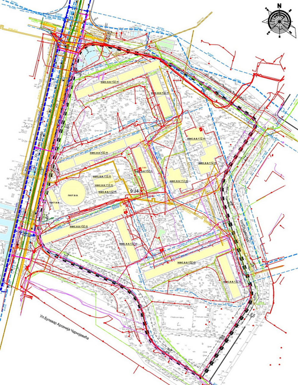
Figure 21. Excerpt from Belgrade GRP, attached figure NB 9.1-S - Overview of infrastructure
Requirements related to protection of cultural properties
If archeological remains or other movable artifacts are found during the execution of earth works within the area covered by the Plan, investors and contractors are obliged to stop the works immediately and inform the Institute for the Protection of Cultural Monuments of the City of Belgrade and take all necessary steps to prevent destruction or damage of the find and to preserve it in the place and position in which it was discovered (Article 109 of the Law on Cultural Properties). According to the Article 110 of the Law on Cultural Properties, the investor is obliged to provide financial resources for research, protection, preservation, publication and exhibition of the property until its transfer for keeping to an authorized protective institution.
Engineering and geological conditions
The area in question is located in the engineering and geological region IIC3 which is characterized as conditionally favorable for urbanization.
The engineering-geological properties of these terrains impose certain restrictions on the urbanization of the area. They include parts of the loess plain from elevation 72.0 to elevation 77.5 above sea level. The use of these terrains during urbanization requires larger investments for their preparation.
It is necessary to take certain meliorative steps during the execution of excavation in this terrain, including potential protection from the effects of underground water and appropriate design of foundation engineering of building structures.
Trenches for laying of pipes can be covered using the processed excavation material. High level of underground water creates unfavorable conditions of excavations for infrastructural building structures and requires complete protection of building structures during their exploitation.
Each newly planned building structure requires detailed geological research, in accordance with the Law on Mining and Geological Research (“Official Gazette of the Republic of Serbia” no. 101/15, 95/18 and 40/21).